
Operational intelligence from video.
Designed for privacy.
Designed for privacy.
We layer AI onto existing CCTV networks to extract real-time metrics—counts, flows, risks—while redacting identities prior to storage or analysis. No hardware replacement required.
the operational blindspot
You have the cameras. You're missing the data.
Infrastructure operators manage thousands of video streams, yet the data is trapped. Manual review is retroactive and slow. Traditional video analytics are a compliance minefield.
The result ?
Critical operational decisions are made without the visual ground truth you already own.
Privacy Deadlock
GDPR risks often prevent the use of standard AI analytics in public spaces.
Data Silos
Footage is stored for security evidence, not analyzed for operational efficiency.
Hardware Costs
Replacing cameras or installing LiDAR across an entire network is cost-prohibitive.
PRIVACY FIRST
How the System Works
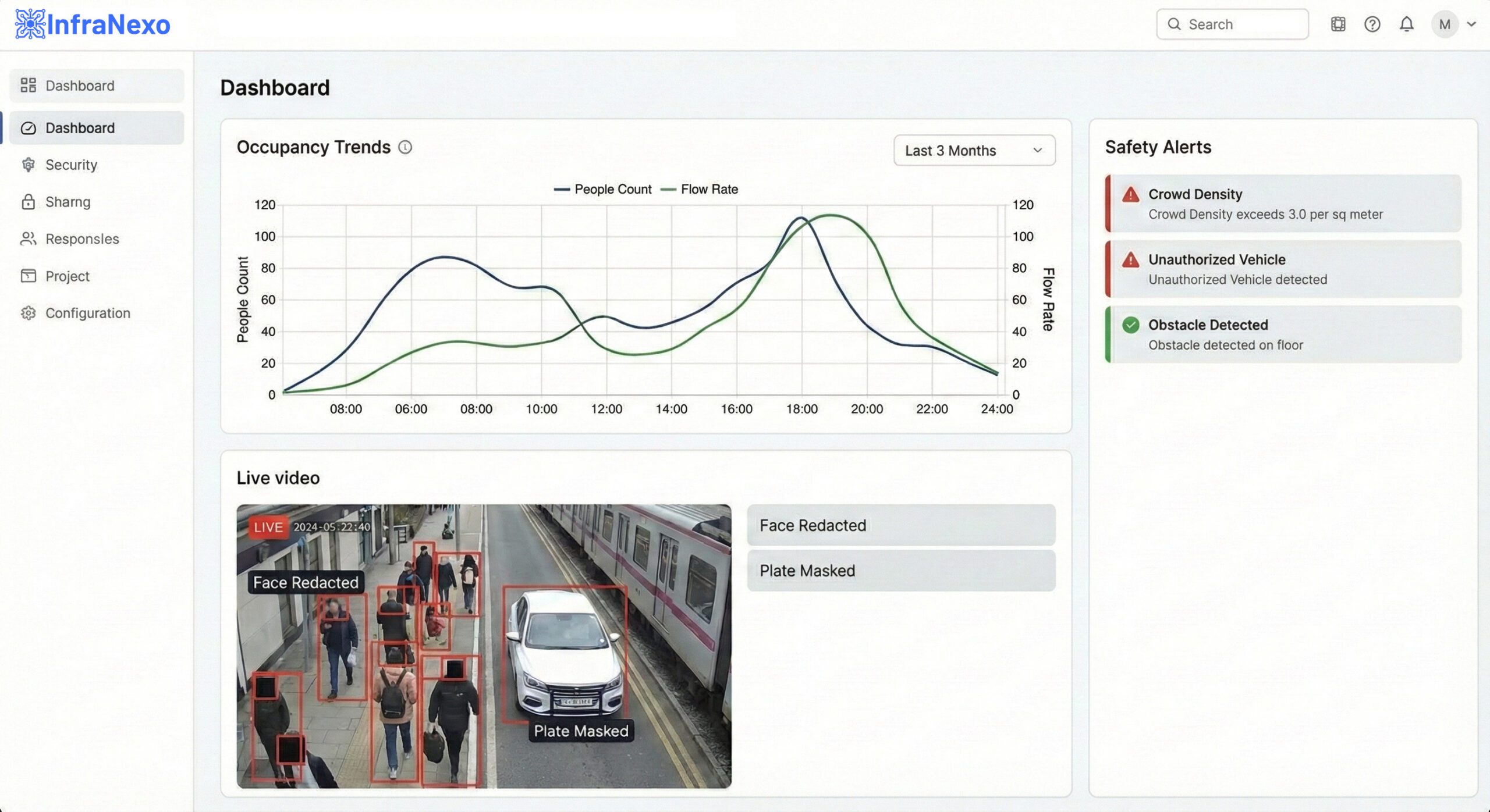
We separate the insight from the identity. The system processes video streams to generate metrics, not surveillance records.
1. Connect
Ingests RTSP streams from your existing IP cameras. No new sensors or hardware replacement.
2. Anonymize
Redacts faces and license plates at the frame level before downstream storage or analysis.
3. Analyze
AI extracts depth, occupancy, flow, and risk events using monocular depth estimation.
4. Insight
Delivers aggregated JSON data, heatmaps, and alerts. Video retention is configurable to customer policy.
Actionable Outputs
Your operations team gets clean, structured data—not just hours of video.
- Occupancy Metrics
- Heatmap Overlays
- Event Timelines
- Safety Alerts
Compliance Architecture
Built for the DPO, not just the COO.
In regulated environments, trust isn't about promises—it's about architecture. Our system is designed to support stringent Data Protection Impact Assessments (DPIAs).
Privacy by Default
We process pixels to generate math. The default state is anonymized.
No Biometrics
Our AI detects "Human", not "Identity". No facial recognition or matching.
Auditability
Logs of data processing activities available for compliance audits.
Compliance Pack Available
- DPIA Starter Template
- Security Controls Overview
- Data Processing Agreement (DPA)
- Logging & Audit Trail Specs
Scope of Capabilities
WHAT WE DO
- Detect objects, flow, and density
- Redact faces and license plates
- Estimate distance via monocular depth
WHAT WE DO NOT DO
- Facial Recognition or Identification
- We do not retain un-redacted footage by default. Retention is customer-configured.
- Sell or share video data with third parties
Technical Detail: Monocular Depth
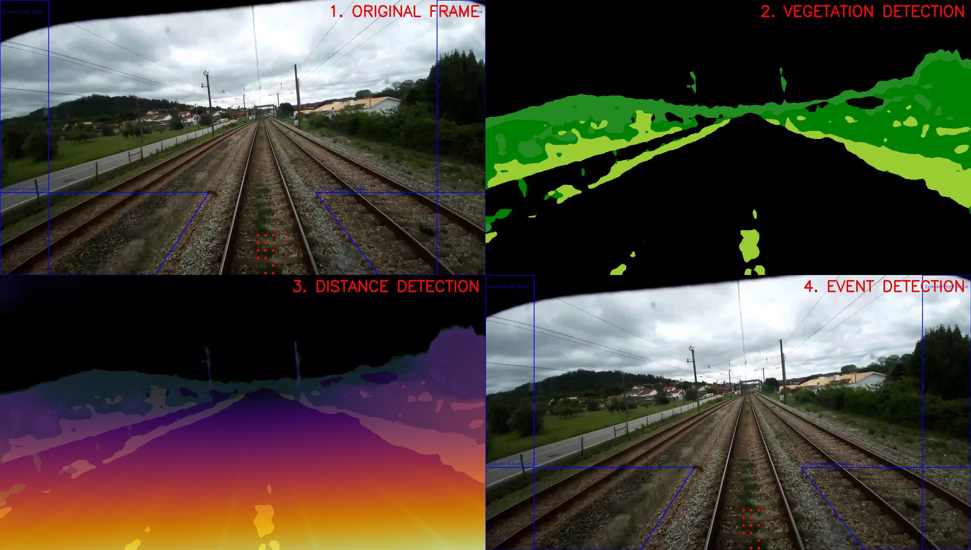
Standard 2D analytics struggle with perspective (e.g., a person far away looks small). We utilize advanced deep learning models to infer a 3D depth map from a single 2D camera feed.
This allows us to calculate real-world distance (meters) and density (people per m²) without expensive stereo cameras or LiDAR.
Targeted applications for critical infrastructure
Validating Use-Cases
Railway
Vegetation management and trackside obstacle detection.
Mobility
Safety zone monitoring for depots and tracks.
Aviation
Analyze curbside congestion patterns and terminal dwell times to identify operational bottlenecks.
Public Space
Crowd density and compliance monitoring.
Structured Pilot Program
We select partners for focused proof-of-value deployments. Define the KPI. Run for 4 weeks. Measure the impact.
4-8 Weeks
Duration
Remote/Hybrid
Setup
Use of Existing
Hardware
Fixed Scope
Terms
pilot use case
Railway Infrastructure
Automated vegetation and obstacle detection from rolling stock.
The Operational Problem
- Vegetation encroachment causes major delays and safety incidents
- Manual inspections are infrequent, expensive, and subjective
- Installing new LiDAR sensors on rolling stock is technically complex
Pilot Deployment
- Ingest video streams from an existing track-facing optical cameras
- Detect vegetation density and trackside assets in real-time
- Apply monocular depth estimation to identify and flag proximity-related risks
- Automated blurring of public faces at stations/crossings
Measurable ROI
- Predictive maintenance scheduling vs reactive clearing
- Significant reduction in the time required for manual video review
- Consistent, objective hazard scoring across the network
- Supports GDPR-aligned inspection records with audit trails
pilot use case
Airport Operations
Optimizing landside flow and curbside dwell times.
The Operational Problem
- Curbside congestion creates bottlenecks for the entire terminal
- Static staff allocation doesn't match real-time passenger peaks
- Strict privacy laws prevent use of facial recognition for tracking
Pilot Deployment
- Analyze vehicle dwell times at designated drop-off zones.
- Track passenger queue density at check-in and security
- Generate occupancy heatmaps for facilities management
- Privacy-preserving processing: no license plate reading or face matching
Measurable ROI
- Dynamic staff redeployment based on real-time alerts
- Provide data to support improvements in passenger flow
- Enable data-driven decision-making for terminal capacity planning
- Provide audit-ready privacy reports for relevant stakeholders
pilot use case
Automotive & Mobility
Safety monitoring for test tracks and smart depots.
The Operational Problem
- Proving grounds require constant monitoring for safety breaches
- Instrumentation costs required for full coverage are prohibitive.
- Sharing test data with partners is difficult due to privacy risks
Pilot Deployment
- Virtual safety perimeters using existing surveillance cams
- Automated alerts for unauthorized personnel in hazard zones
- Anonymization layer allows safe video sharing with 3rd parties
- 3D positioning of vehicles from standard 2D video
Measurable ROI
- Provide operational alerts for detected safety violations.
- Reduced insurance liability through continuous active monitoring.
- Accelerated validation cycles via easier data sharing
- Low-cost deployment using standard infrastructure
pilot use case
Public Infrastructure
Crowd safety and asset management for smart cities.
The Operational Problem
- City planners lack granular data on public space usage
- Surveillance privacy concerns block smart city initiatives
- Incident response is reactive, relying on citizen reports
Pilot Deployment
- Crowd density counting and flow analysis
- Detection of abnormal events (e.g., running, converging)
- Traffic flow metrics without ANPR/identifiable data
- Privacy-first architecture acceptable to city councils
Measurable ROI
- Objective data for urban planning and zoning
- Enable faster response times to overcrowding or accident events.
- Public trust through transparent privacy tech
- Cost-effective monitoring of vast public areas
Contact Us
Start a pilot conversation
No obligation. No hardware changes. Clear scope upfront.
InfraNexo.com All rights reserved. Imprint